A continuation of the Feb 20, 2012 post of the ongoing changes being done to the Blair Sub between Missouri Valley, IA and E. Fremont, NE. For ease of reference I have created this
Blair Sub changes map
Missouri Valley, IA
Crews continue to work on the configuration changes needed for the junction of the Boone, Omaha and Blair subs. Once completed the junction with be configured with the Omaha Sub east bound connections being moved further to the east in Missouri Valley and the west bound connection curvature eased.
Switch heater gas lines and signal bases are currently being worked on. The signal boxes have all been moved further away from the current ROW to allow for the new alignments.
 |
| E. Missouri Valley, IA looking east. |
 |
| E. Missouri Valley looking west. |
 |
| Current Omaha Sub connector |
 |
| Looking toward east Missouri Valley |
A curious note is the land owner who owns the land section on the south side of the ROW have erected 'No Trespassing' signs and positioned large trees along the border to prevent incursion on to his land. This individual is a charmer as I have encountered him once (which was enough) while on the side of S. 6th St. video taping some east bounds. Like most isolated small town people he is more than opinionated about his vision of the world. He is also the owner of the local gun shop which makes him even more charming.
Allen Creek to California Jct., IA
Around Italy Ave, not much activity has occurred since February. The ROW has been mostly used as an access road. The new switch for main two just to the east of Italy Ave is now completed but has not been cut in.
New signaling has been installed about half way between Italy Ave and Grover Ave.There are four signal masts positioned in this area for the new main two and main three tracks. It is unknown if there will be a set of cross overs at this location or it this will be a new interlocking.
 |
| New main two looking west from Italy Ave. |
 |
| Looking est toward the Allen Creek interlocking. |
 |
| New switch for main two just east of Italy Ave. |
Most of the current activity is currently occurring east of California Jct on this segment. A new switch has been installed from the current main to the new main 2 ROW about 100 yards east of Fremont Ave. This switch is currently leading to nowhere.
 |
| Looking east from Fremont Ave. |
 |
| The new switch can be seen in this photo. |
California Jct to Corning Ave.
Work has progressed on the new ROW from California Jct to Corning Ave since Febuary. Most of the work is currently concentrated at the slough to the west of Austin Ave. Bridge work has begun in earnest with the UP building a temp berm out into the slough to allow for pilings to be driven.
At California Jct. new CTC signals are being installed to replace the searchlight signals currently in place.
 |
| Looking west from Fremont Ave at new ROW. New signals can bee seen in the distance. |
 |
| Looking east from Austin Ave. Drainage work is still ongoing in this section. |
 |
| Looking west from Austin Ave. |
 |
| The temp berm alongside the current bridge at the slough. |
The work around Corning Ave is confusing as the northwest corner of the crossing are has ROW prep work occurring while the northeast corner does not. There is no evidence that this are will be used with this project as it is untouched.
 |
| Corning Ave northwest side looking west. |
 |
| Looking east at the northeast side of Corning Ave. |
 |
| Looking east at the work area where the new bridge over the slough will be. |
Corning Ave to Hwy 92 Blair, NE
Crews are working on the Iowa side of the Missouri River bridge incline. This area is off limits and no work can be observed from the Blair side or Iowa side.
No activity or survey markers where noted between the Missouri River and CP Duffy.
CP Duffy to Kennard, NE
This section of double track is in use.
Kennard to Arlington Hill.
The old Kennard siding has been completely removed and realignment work begun west of the Papio Creek bridge west of Kennard proper.This involves cutting into the hill along the south side of the ROW and moving the old siding ROW to this new alignment.
 |
| Looking west toward the old East Kennard siding switch. |
 |
| Current start of double track looking east at Kennard. |
 |
| New alignment for the old Kennard siding area. |
Work continues on the two bridges over the Papio creek tributaries that were crossed by the old Kennard siding. No other work was observed on the new ROW that will replace the old Kennard siding though.
 |
| East crossing of the Papio creek |
 |
| Removed Kennard siding looking west. |
 |
| Bridge work on the west end of the old Kennard siding. |
The access road that was used to gain access to the switches at West Kennard has been removed as crews are currently widening the "cut" under the Hwy 30 overpass. Heavy equipment is positioned in the field between the creek bridge and Hwy 30 for use on the ROW build west of Hwy 30 to Co Rd 21.
East of Co Rd 21 to Hwy 30 has not seen any work other than drainage and tree clearing. With the heavy equipment positioned east of Hwy 30 this may soon change. The excavation work west of Co Rd 21 appears to be completed for now.This work is observable on the satellite image of the Blair Sub changes map. The curve will be changed in this are to allow for higher speeds.
 |
| Looking east from C Rd 21 toward Hwy 30 |
 |
| Drainage work at Co Rd 21. |
 |
| New ROW between Co Rd 21 and Co Rd 19. |
At Co Rd 19 rough excavation work was observed for drainage and signal cabling. A UP crew was also observed working on the CTC signal shack east of the Co Rd. 21 crossing.
 |
| Looking south at the Co Rd 19 crossing |
 |
| Looking southeast at the Co Rd 19 crossing |
 |
| Looking east toward the Co Rd 21. |
The summit of Arlington Hill has had major excavation work done. The narrow cut is now widened and the south side of the hill contoured with a tapered slope. Just easy of Co Rd 34 drainage pipes have been staged for use in drainage work.
East of Co Rd 34 to Co Rd 21 no excavation work was observed. Tree and brush has been removed and rough access paths have been cut in though.
 |
| Looking west from Co Rd 34 at the summit of Arlington Hill. |
Arlington Hill summit to Arlington, NE
The old tree farm at the summit of Arlington Hill appears to be UP property now. Material and equipment was noted staged on the property and the house is empty.
The west side of Arlington Hill has has a number of changes made to it. The cut atthe summit has been widened and the ROW shifted to the north.
 |
| Arlington Hill summit west side changes. |
West of Co Rd 15 the excavation work for the elimination of the s-curve is nearing rough completion. Culvert and drainage work was observed along the ROW heading west from this crossing.
 |
| Excavation work to eliminate the s-curve. |
From Co Rd 15 to Co Rd P11 the ROW is away from the road and can not be directly observed. It was possible to see through the trees culvert and drainage work being done and some excavation work for the new ROW.
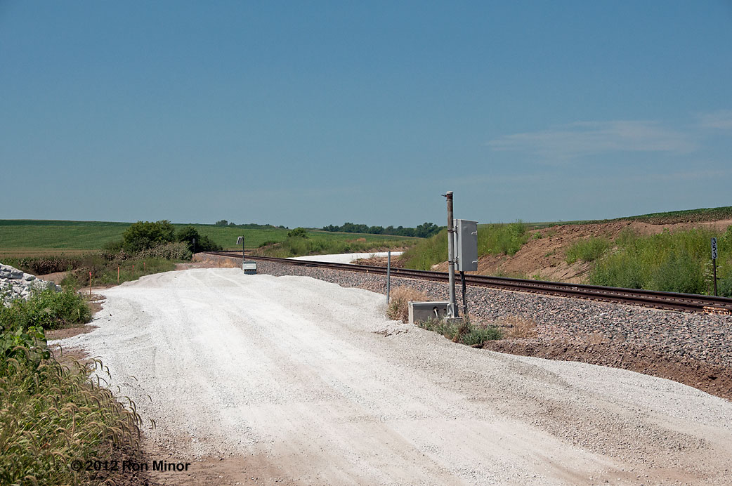
At Co Rd P11 excavation work was observed on the north side of the current ROW. The new main will shift over to this side somewhere on Arlington Hill as it will be on the south side of the existing ROW from Kennard to Arlington Hill.
 |
| Looking north east from the Co Rd P11 crossing. |
 |
| Looking south west from the Co Rd P11 crossing. |
Survey stakes are now seen through Arlington with the new alignment going between the existing main and the town. I had been lead to believe that the ROW would have used the old Elkhorn ROW through Arlington. No excavation work was noted through Arlington up to E. Fremont.